Geometry
Turn polygon data into H3 cells directly in Polars. If your data has one area
per row—such as a census tract, delivery zone, or neighborhood—
polygon_to_cells adds the H3 cells that cover each area.
You do not need GeoPandas or a special Polars geometry type. The original polygon and its attributes stay in the same row, so the result fits naturally into an existing Polars pipeline.
Read polygons from GeoParquet
GeoParquet is the shortest path. Read the file with Polars and pass its
geometry column—usually named geometry—to polygon_to_cells:
import polars as pl
import polars_h3 as plh3

covered = (
    pl.scan_parquet("areas.parquet")
    .with_columns(
        h3_cells=plh3.polygon_to_cells("geometry", resolution=9)
    )
)
That is enough to go from stored polygons to H3 coverage. covered keeps every
source column and adds an h3_cells list to each row. Because this example uses
scan_parquet, it also stays lazy until you collect the result.
What are WKT and WKB?
They are two common ways to store geometry. WKT is readable text such as
POLYGON (...); WKB stores the same shape as compact bytes. GeoParquet
normally uses WKB.
polygon_to_cells accepts both: Polars String columns are read as WKT,
and Binary columns are read as standard WKB or PostGIS EWKB. An explicit
EWKB SRID must be 4326.
Check the geometry column
WKB geometry must appear in Polars as Binary. GeoArrow native geometry
encodings are not currently accepted. You can inspect a lazy input without
loading the data:
Read polygons from GeoJSON
Polars does not decode GeoJSON geometry by itself. Pyogrio can read the file and hand the polygons to Polars as WKB:
import pyogrio
import polars as pl
import polars_h3 as plh3

metadata, arrow_table = pyogrio.read_arrow("areas.geojson")
geometry_column = metadata["geometry_name"] or "wkb_geometry"

covered = pl.from_arrow(arrow_table).with_columns(
    h3_cells=plh3.polygon_to_cells(geometry_column, resolution=9)
)
The result has the same shape as the GeoParquet example: source attributes,
the original geometry, and one h3_cells list per polygon.
Compatibility with Polars earlier than 1.36.0
Polars 1.36.0 added Arrow extension-type support.
It loads Pyogrio's geoarrow.wkb geometry as its physical Binary storage
type. With an earlier Polars release, remove the field annotation before
converting the table if the GeoArrow extension type is reported as
unsupported. The WKB bytes themselves are unchanged:
import pyarrow as pa

geometry_index = arrow_table.schema.get_field_index(geometry_column)
arrow_table = arrow_table.set_column(
    geometry_index,
    geometry_column,
    arrow_table[geometry_column].cast(pa.binary()),
)

covered = pl.from_arrow(arrow_table).with_columns(
    h3_cells=plh3.polygon_to_cells(geometry_column, resolution=9)
)
Work with the resulting cells
To produce one row per polygon/cell pair, explode the list:
Distribute feature metrics across cells
To divide a metric such as census-tract population evenly across every H3 cell selected for that feature, divide by the list length before exploding. Other feature columns are duplicated onto each resulting cell row:
metric_columns = ["population"]

feature_cells = (
    covered
    .with_columns(cell_count=pl.col("h3_cells").list.len())
    .filter(pl.col("cell_count") > 0)
    .with_columns(
        [
            (pl.col(column) / pl.col("cell_count")).alias(column)
            for column in metric_columns
        ]
    )
    .explode("h3_cells")
    .rename({"h3_cells": "h3_cell"})
)
Overlapping source features can then be combined by cell:
This preserves each non-empty feature's metric total, apart from normal floating-point rounding. It is an equal-allocation model, not areal interpolation: cells are selected when their centroids lie inside the source polygon, and every selected cell receives the same share. Features whose coverage is empty at the chosen resolution are removed by the explicit filter; use a finer resolution or define a fallback policy if those features must be retained.
To visually compare the source polygons with their H3 coverage, pass the row-aligned geometry and list columns directly to the optional Folium helper:
coverage_frame = (
    covered.collect() if isinstance(covered, pl.LazyFrame) else covered
)
coverage_map = plh3.graphing.plot_polygon_coverage(
    coverage_frame,
    geometry_col=geometry_column,
    cells_col="h3_cells",
)
coverage_map
The helper accepts WKT or WKB geometry and scalar or list H3 cells. It draws the source geometry and deduplicated cells as separate toggleable layers.
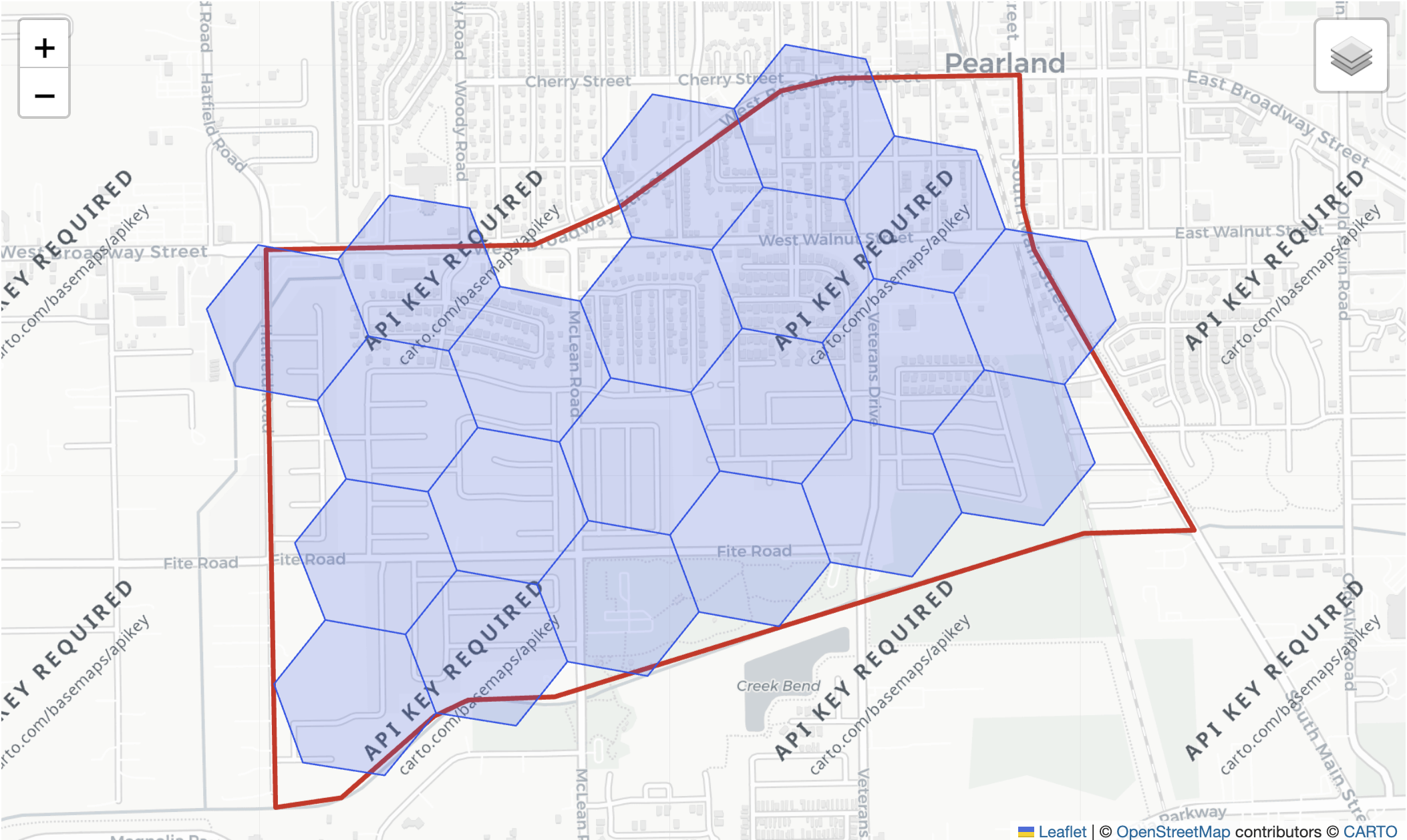
The example shows centroid-based coverage: selected cell boundaries may extend beyond the source polygon. See the graphing reference for null, scale, and antimeridian behavior.
Coordinate reference system
H3 expects WGS84 longitude/latitude coordinates. polygon_to_cells parses
geometry bytes or text but does not inspect GeoParquet CRS metadata or
reproject coordinates. Reproject non-WGS84 data before this step.
polygon_to_cells
Return every H3 cell whose centroid is inside each polygon or multipolygon.
Input may be WKB/EWKB Binary or WKT String. Explicit EWKB SRIDs must be
4326. Polygon holes and antimeridian-crossing geometries are supported. The
result has dtype List(UInt64).
import polars as pl
import polars_h3 as plh3

df = pl.DataFrame(
    {
        "geometry": [
            "POLYGON((-122.42 37.77,-122.40 37.77,-122.40 37.79,"
            "-122.42 37.79,-122.42 37.77))"
        ]
    }
)

df.select(cells=plh3.polygon_to_cells("geometry", resolution=9))
Null input rows produce null output rows. Malformed WKT/WKB, non-polygon
geometry, and invalid polygon coordinates raise
polars.exceptions.ComputeError.
polygon_wkt_to_cells
Compatibility wrapper for WKT inputs. New code should prefer
polygon_to_cells, which also accepts WKB Binary columns.
cells_to_multi_polygon_wkt
Dissolve each list of H3 cells into one MULTIPOLYGON WKT string. Shared cell
edges are removed from the result. List elements may be UInt64, Int64, or
hexadecimal strings, but every row must contain unique cells at one resolution.
df = pl.DataFrame(
    {"cells": [["8928308280fffff", "8928308280bffff"]]}
)

df.select(geometry=plh3.cells_to_multi_polygon_wkt("cells"))
An empty list produces MULTIPOLYGON EMPTY, and a null list produces null.
Invalid, duplicate, or mixed-resolution cells raise
polars.exceptions.ComputeError.
Coordinate order
WKT and WKB follow X/Y order: longitude first, then latitude. This differs
from cell_to_boundary, which returns nested [latitude, longitude] lists.